Light single-engine aircraft over terrain
EFB · From $7.99 / mo

An EFB built around an aviation-trained AI.

FAA-cycle charts, real terrain, real winds, real NOTAMs — fed into an assistant that briefs your route in the format the examiner expects, and writes your logbook from the voice memo you record at shutdown.

FAA CHART CYCLE28 d
CHART LAYERS6
WX PRODUCTSMETAR · TAF · SIGMET · NEXRAD · PIREP
CURRENCY TRACKERFAR 61.57

An AI built for aviation, not borrowed from somewhere else.

Most “AI for pilots” is a chatbot in a costume. Ours is grounded in real DEM terrain, current winds aloft, active NOTAMs & TFRs, FAA publications, and your actual filed route. It reads aviation. It speaks aviation. It knows when to be quiet.

  1. 01
    ROUTE BRIEF

    Streams a structured pre-flight brief: surface winds, winds aloft at your cruise, METAR/TAF for every reporting station along the route, active TFRs and SIGMETs, terrain clearance for each leg. In the format the FAA examiner expects.

  2. 02
    WEATHER READ

    Takes the raw METAR (“231453Z 25008G18KT 6SM -RA BR OVC012”) and tells you what it means: MVFR, ceiling 1,200, light rain with gust factor 10kt. In the words a CFI would use, not a chatbot.

  3. 03
    VOICE DEBRIEF → LOGBOOK

    Record a memo on the ramp at shutdown. The assistant parses crosswind, approach quality, learning notes, and writes a structured logbook entry that imports cleanly into ForeFlight or MyFlightbook.

  4. 04
    RADIO QUIET

    Stays out of your way during taxi, runup, and pattern work. Only speaks when you ask, or when something on the chart changes that you need to know about.

Real FAA charts. Real weather. Same projection.

Charts pull on the 28-day NACO cycle — same effective dates as the books in the right seat. Weather products from NWS render on the same projection as your route, not tacked on top.

Sectional · TAC · IFR

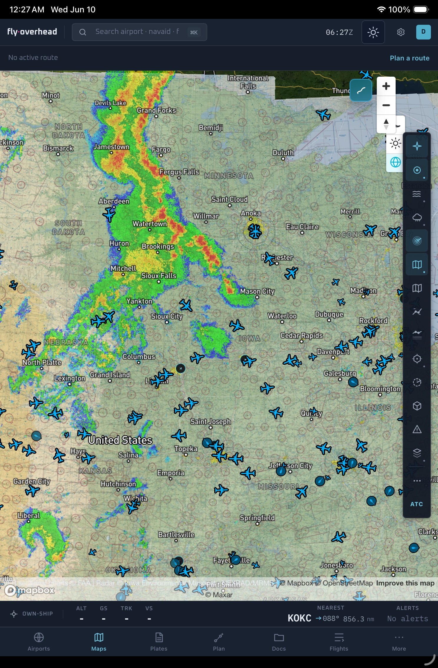
Six chart products on a single projection

VFR sectional, terminal area chart (TAC), IFR low and high enroute, instrument approach plates (IAP), SIDs and STARs. Pinch-zoom across all six without losing your bearings — Mapbox GL keeps the projection continuous.

SEC1:500,000EFF 25 MAY
TAC1:250,000EFF 25 MAY
IFR-L1:1,500,000EFF 22 MAY
IFR-H1:3,000,000EFF 22 MAY
Live weather

METAR / TAF / NEXRAD / PIREP / SIGMET

Surface obs every minute, NEXRAD radar every 5, PIREPs as they come in. Decoded cards or raw strings, your choice. The AI assistant cross-references the raw data against your filed altitude and reports back in plain pilot English.

SIGMET · ZOA · LIVEWSUS01 KKCI 251457 SIGE TURB FCST WI AREA BTN 040Z-080Z FROM 60N 100W TO 50N 110W TO 50N 80W TO 60N 80W ... OBS MOD TURB BLW FL180
Live traffic

The public tracker, on top of your chart

The same ADS-B feed mesh that powers the free public tracker, layered onto your EFB chart at the same projection. See the IFR arrival flow into your destination before you push the throttle.

JBU65BCS3 · FL340 · CLEARED RWY 26
N172JMC172 · FL085 · 6 NM TRAILING
N91247P28A · FL055 · LEVEL OFF
Cockpit instrument panel at altitude

“I file VFR, get a brief, fly the leg, record the voice memo at shutdown. The logbook entry is already there when I park the airplane. I haven’t hand-written a logbook entry in three months.”

M. HalversonPPL · KSEA → KFHR · Cessna 182

Install once. Fly with whatever you brought.

Progressive Web App. Same install on iPad, iPhone, Android, Mac, Windows. Charts cache offline. No app store gate. No vendor lock. No per-device license.

  • iPadyoke, kneeboard, panel mountPWA installs from any browser
  • iPhoneright seat, pocket, backupTouch-rendered for kneeboard use
  • Androidphone or tabletSame install, same charts cache
  • LaptopFBO desk, dispatch room, planningFull-resolution chart layers
PWAAdd to Home Screen on iPad, install from Chrome on Android, drop a shortcut on the macOS dock — same app, same data, same sign-in.
Aircraft over terrain
Begin

$7.99 / month. No vendor lock.

Basic plan is the chart layer + traffic + weather. Pro adds the AI assistant, voice debrief, and the unlimited logbook. Both are month-to-month. Cancel any time. Export your logbook in CSV, GPX, or KML on the way out.